FISHING BRIEF
Memorial Day, Monday May 25, 2026 // Mouse Island, Lake Erie Western Basin
Cleanest Western Basin day in weeks: light variable wind shifting to E under 10 kt, 1 ft or less of chop, no advisories, mostly sunny. Water now 55°F (up 1° from yesterday) so walleye still slow and reef-oriented but warming into the strike zone. Best play: jig the Mouse Island reef edge in 10-14 FOW with a 3/8 oz hair jig (purple/chartreuse). All-day fishable — no storm window today, unlike yesterday.
W 82° 49.962'
W 82° 41.000'
W 82° 58.390'
⬇ DOWNLOAD ALL 7 WAYPOINTS (.GPX)
Full list (launch + 6 fishing spots including Crib + Toussaint Reefs as alternates) in section 03 below.
01Jet-Ski Call — GO (all day) NWS LEZ143 + alerts API · pulled 9:30 AM ET · live data on refresh
Today is a green-light day with no afternoon weather pressure. Sub-10 kt wind, 1-ft waves, no storms in the forecast. Launch any time after 7 AM and stay out until dinner if you want. Catawba Point Association ramp (your home launch right at Mouse Island) is the natural choice with this wind direction.
02What's Biting lakeeriefish.com · pulled 9:35 AM ET
- Walleye: Same pattern as the weekend — slow start, Mouse Island / Middle Bass / Marblehead named as high-current trolling zones. Toussaint / Round / Niagara Reefs for jigging. Trolling 19-28 FOW at 1.0-1.8 mph. Jigging 10-16 FOW on rocky reef outskirts. Target bottom 5-6 ft as fish enter/exit reefs.
- Smallmouth bass: 55°F is right at staging temp. Pre-spawn smallies on rocky points around Bass Islands. Tube jigs + suspending jerkbaits in rusty/brown or perch.
- Perch: Not yet. Watch for first reports mid-June.
- White bass: No blitz reports yet. Watch as water hits upper 50s in the next 1-2 weeks.
02bRecent Angler Reports (Facebook) loading...
02cWater Clarity (NASA MODIS satellite) NASA Worldview · 250 m/pixel · today's pass
Two satellites pass over Lake Erie daily. Use these to spot sediment plumes (muddy west end from Maumee River runoff), algae blooms (green/turquoise patches), and clearer water (deep blue). Walleye prefer stained but not muddy water — pick areas where the plume is fading into clearer blue.
TERRA · ~10:30 AM EDT pass · click for interactive view
AQUA · ~1:30 PM EDT pass · click for interactive view
Light tan / brown: heavy sediment plume (skip these areas, walleye won't see your bait).
Turquoise / green: algae or moderately stained water (often productive for walleye in spring).
Deep blue: clear water (good for visual feeders like smallmouth; walleye need lower light).
Plume edges: where muddy meets clear = the sweet spot. Walleye stack on these color boundaries.
If both passes are mostly cloud, the previous day's imagery is usually still relevant (sediment patterns change slowly day-to-day). Open the Worldview interactive viewer and step back a day or two with the date slider.
03Where to Go (from Catawba launch) static for the day
- Install Garmin ActiveCaptain on your iPhone (free)
- On the ECHOMAP:
Settings » Communications » ActiveCaptain→ enable Wi-Fi - Open the app on your phone, follow the pairing prompt (joins the chartplotter's Wi-Fi)
- Open this brief on your phone (
reel.quest/today) - Tap the DOWNLOAD .GPX button above
- iOS Share sheet pops up → tap ActiveCaptain → waypoints auto-load and sync wirelessly to your ECHOMAP
Each waypoint below also has an "Open in Maps" link — tap to see the spot in Apple Maps for visualization, even without ActiveCaptain set up yet.
hddd°mm.mmm'. Type them in exactly as shown. If your unit is set to a different format, change at Settings » Units » Position Format.
[MED] = published but center-of-feature only; fish hold on the edges, not the point.
[LOW] = my best guess from satellite or vague intel. Verify yourself.
Always: the waypoint is a starting point. Fish hold on drop-offs and current breaks, usually 50-200 yards off the named coord. Read your fish finder when you arrive.
- Catawba Point Association ramp (launch). [LOW] Your home ramp at Mouse Island. Drop a pin at the actual ramp and tell me — I'll re-deploy in 30 sec.
> N 41° 35.280', W 82° 50.400' 📍 Open in Maps - Mouse Island REEF [HIGH — Natural Atlas] — the actual fishing structure, NOT at the island. ~1.2 nm NNE of launch. Limestone shoal, 0.33 sq mi, least depth 9 ft. Edges drop into 18-22 FOW. Jig the perimeter, not the top.
> N 41° 36.402', W 82° 49.962' 📍 Open in Maps - Niagara Reef (lighted buoy 5). [HIGH — Coe Vanna Charters] ~6 nm WNW of launch. The lit buoy marks the reef. Jig the rocky edges.
> N 41° 39.840', W 82° 58.390' 📍 Open in Maps - Crib Reef (buoy 7). [HIGH — Coe Vanna Charters] ~10 nm NE. The buoy 7 marks it. Less crowded than Niagara, productive in similar patterns.
> N 41° 38.820', W 82° 39.990' 📍 Open in Maps - Toussaint Reef. [HIGH — Coe Vanna Charters] ~9 nm W. Named in this week's lakeeriefish.
> N 41° 36.660', W 83° 01.240' 📍 Open in Maps - Marblehead current zone. [LOW — my guess off lighthouse] ~3-4 nm E. Troll Husky Jerk or Reef Runner in 18-22 FOW where current breaks the point. Verify the exact current break with your fish finder.
> N 41° 32.400', W 82° 42.300' 📍 Open in Maps - Open basin N of Kelleys. [LOW — FB intel only] From Cesar Ho FB report 5hr ago: 38-44 FOW, worm harness w/ gold blade, noon-6 PM. No named reef — open basin. Run NE until your finder shows 38-44 FOW and bait clouds. Approximate target:
> N 41° 41.000', W 82° 41.000' 📍 Open in Maps
NOAA Chart 14830 — authoritative Western Lake Erie chart, all named reefs and depths.
Coe Vanna Charters reef coord list — where the buoy/reef coords above came from. Cross-check before you save them in your Garmin.
04What to Throw verified product links · check before buying
Today's recommended lures, each linking to a product page (with photo) and the technique walkthrough. Open the product link to compare against what you already own.
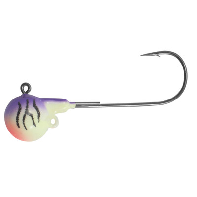
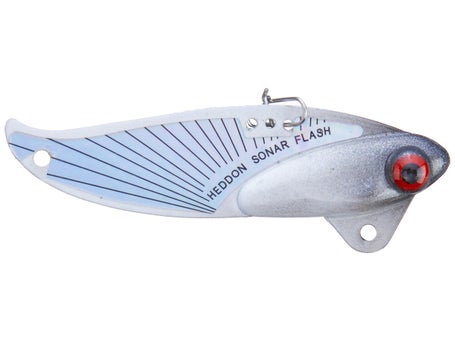
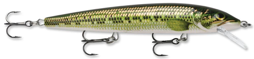


> The TECHNIQUES tab shows the full library including how to read the fish finder, which is critical on every reef trip.
05Beginner Notes
- No planer boards from the jet ski. One hand on throttle, one on rod. Jigging or short-line trolling only.
- Slow at 55°F. Walleye still cool-water mode. Drag jigs slow, troll low end. If no bite in 20 min, move 200 yards.
- DDM coordinates only. Your Garmin defaults to
hddd°mm.mmm'. Decimal degrees won't input correctly unless you change Settings » Units » Position Format.
06Sources Pulled
- NWS active alerts (api.weather.gov, 9:30 AM ET 5/25): None active for Ottawa County.
- NOAA LEZ143 nearshore (Reno Beach to The Islands OH): pulled, no advisories. Issued 3:40 AM EDT 5/25.
- NWS point forecast (Catawba lat/lon): pulled, mostly cloudy AM → mostly sunny, high 75°F.
- Buoy 45005 (West Lake Erie): water 55°F, wind 3.9 kt NNE at 9:10 AM EDT.
- lakeeriefish.com Western Basin: pulled. Same pattern as weekend — slow start, walleye reef-oriented.
- FB groups SKIPPED: Autonomous FB scraping blocked by anti-bot (documented in skill). Run /fishing-report locally for inline scrape attempt.
The full technique library. Each is a standalone page with setup, presentation, what a strike feels like, the one mistake to avoid, and a "Further reading" section with vetted videos + sites. Today's brief specifically recommended vertical jigging, blade baits, short-line trolling, and reading the fish finder — those are tagged below.
Every technique that has ever been recommended in a brief lives in the library. New techniques get added when a brief recommends them for the first time.